
Welcome to Austin Drilling & Well Repair Inc., your trusted well repair company in Columbia, South Carolina. Today, we delve deeper into the fascinating world of aquifer mapping—an essential practice that holds the key to understanding the complexities of groundwater resources. As a leading well drilling contractor in Columbia, we recognize the utmost significance of aquifer mapping in providing reliable water solutions to our valued customers. In this comprehensive article, we’ll explore what aquifer mapping entails, its importance, and how it benefits both our community and your well system.
Understanding Aquifer Mapping: Aquifer mapping is a systematic and scientific process that involves evaluating and charting the characteristics and distribution of underground aquifers. These aquifers are porous rock formations that hold and transmit groundwater, making them vital sources of water for wells and communities alike. Through meticulous research and data analysis, our team at Austin Drilling & Well Repair Inc. gains valuable insights into the hydrogeological conditions beneath the Earth’s surface.
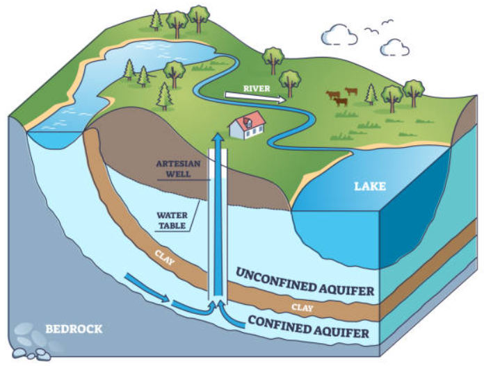 In layman’s terms, think of an aquifer as a vast, subterranean water storage tank. These natural reservoirs are contained within layers of permeable rock, gravel, sand, or silt from which water can be extracted. Aquifers play a crucial role in sustaining ecosystems and human societies by providing a reliable water source.
Before we dive in-depth into the aquifer mapping process, let’s quickly outline why this process is so essential. Aquifer mapping enables us to understand where our underground water resources are located and how much water they hold. This knowledge is paramount for responsible water management, ensuring we use these precious resources wisely without depleting them for future generations.
The Importance of Aquifer Mapping
Aquifer mapping serves several crucial purposes, contributing to informed decision-making and sustainable water management:
- Identifying Suitable Well Sites: One of the primary benefits of aquifer mapping is the ability to pinpoint locations with the highest potential for productive wells. By understanding the geological composition and the hydrological behavior of the aquifers in a specific area, we can recommend the best well site for your particular water needs. This optimization not only enhances water yield but also minimizes drilling costs.
- Assessing Water Quality: Understanding the geological makeup of aquifers allows us to anticipate potential water quality issues. Different rock formations can affect the composition of groundwater, leading to variations in mineral content or the presence of contaminants. With aquifer mapping, we can identify these characteristics early on and implement appropriate filtration and treatment measures to ensure your well water is safe for consumption.
- Predicting Water Availability: In regions where water scarcity is a concern, aquifer mapping becomes an invaluable tool for estimating water availability. By analyzing historical groundwater levels and considering the hydrological balance, our team can project future trends in water supply. This information is crucial for managing water resources effectively, especially during periods of drought or high demand.
- Conservation Planning: Armed with aquifer data, our team can collaborate with local authorities and communities to develop sustainable water conservation plans. These initiatives focus on responsible water usage, preventing over-extraction, and promoting practices that protect groundwater reserves for future generations.
The Process of Aquifer Mapping
At Austin Drilling & Well Repair Inc., our aquifer mapping process is comprehensive and precise:
- Geological Surveys: We commence by conducting detailed geological surveys of the area surrounding the potential well site. These surveys involve studying rock formations, soil characteristics, and any existing wells nearby.
- Groundwater Monitoring: Our team installs monitoring wells strategically to measure groundwater levels and monitor fluctuations over time. This ongoing monitoring provides essential data to understand aquifer dynamics.
- Geophysical Techniques: Utilizing advanced geophysical methods, we map subsurface structures and identify potential aquifer boundaries. These techniques can include seismic surveys, resistivity surveys, and electromagnetic surveys.
- Data Analysis: Our experts meticulously analyze the data collected during geological surveys and groundwater monitoring. This data includes geological reports, hydrogeological data, and well logs.
- Hydrogeological Models: We develop sophisticated hydrogeological models that help us visualize water flow patterns and the behavior of aquifers in response to various factors.
Aquifer mapping is an indispensable tool in the world of groundwater exploration and well drilling. At Austin Drilling & Well Repair Inc., our commitment to understanding aquifers empowers us to provide efficient and effective well solutions to the Columbia, South Carolina community. With aquifer mapping guiding our endeavors, we ensure sustainable water resources for your well system, guaranteeing a consistent and reliable water supply for years to come. Trust Austin Drilling & Well Repair Inc. for all your well-related needs and experience the difference of working with a team dedicated to excellence and customer satisfaction.

